Buckeye Hot Springs
Natural geothermal hot springs near Bridgeport, California, where hot spring water flows above Buckeye Creek into primitive creekside soaking pools in the Humboldt-Toiyabe National Forest.
Buckeye Hot Springs is a natural geothermal spring area near Bridgeport in Mono County, California. The springs sit above Buckeye Creek in the Humboldt-Toiyabe National Forest, where very hot geothermal water flows from the hillside and mixes with cooler creek water around primitive soaking areas.
Unlike a commercial thermal pool, Buckeye is a rustic outdoor hot-spring experience. The creek, forest, mineral-stained rock and natural hot-water source are the main attraction, while road, weather and seasonal conditions can strongly affect access.
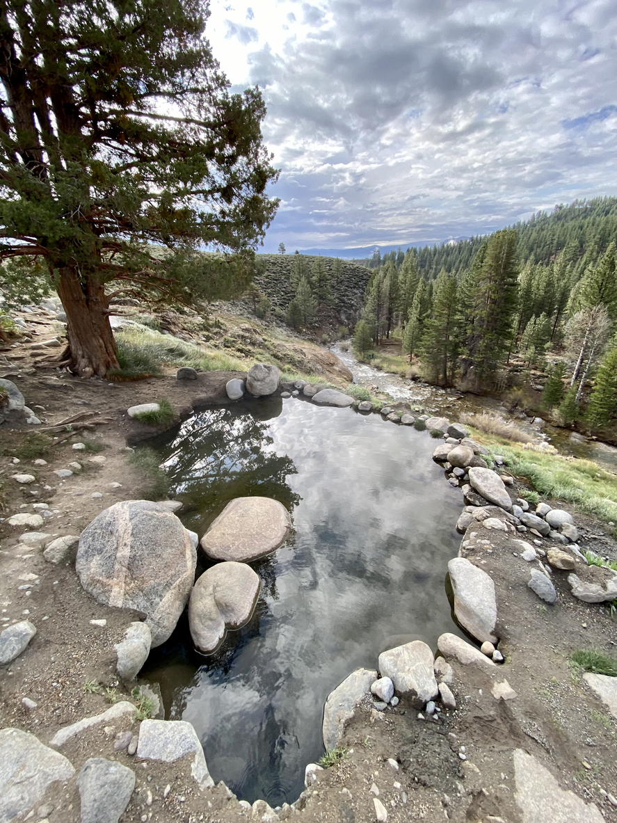
Buckeye Hot Springs near Bridgeport, California. Image licensed through iStock; licence details retained in the NHSNM image licence log.
Quick Facts
- Location: Near Bridgeport, Mono County, California, United States
- Nearest town: Bridgeport
- Spring type: Natural geothermal hot springs
- Recorded source temperature: Approximately 60°C / 140°F
- Soaking temperature: Cooler and variable after hot spring water mixes with surrounding water
- Bathing: Recreational soaking occurs at the site; always follow current Forest Service closures, signs and safety instructions
- Access: Unsealed Buckeye Road followed by short walking access in normal conditions
- Management: Humboldt-Toiyabe National Forest, Bridgeport Ranger District
- Setting: Primitive creekside geothermal soaking area
- Facilities nearby: Vault toilet at the Buckeye Hot Springs parking area; no potable water at nearby Buckeye Campground
- Winter access: Buckeye Road can close to wheeled vehicles when managed as a winter trail
- Nearby related site: Travertine Hot Springs
Why Visit
Buckeye Hot Springs offers a very different experience from a developed spa or municipal thermal pool. The geothermal source emerges above Buckeye Creek, with hot water flowing across mineral-stained rock before reaching primitive soaking areas near the creek. Official Forest Service information carried by Recreation.gov lists the main hot spring at approximately 140°F / 60°C and notes another smaller spring upstream.
The combination of hot water, cold creek water, forest and mountain scenery gives Buckeye a strong natural identity. It is also close enough to Bridgeport to combine with Travertine Hot Springs as part of an Eastern Sierra hot-springs trip.
Bathing Experience
Buckeye is a primitive natural soaking area rather than a maintained swimming complex. The spring water at its source is extremely hot. Recreation.gov lists Buckeye Hot Springs at approximately 140°F / 60°C. That figure should not be treated as the temperature of every soaking area.
Water cools as it moves away from the hottest source and mixes with cooler water around Buckeye Creek. Conditions can vary with spring flow, creek level, weather, season, recent storms and changes to the natural pools. Never enter based only on what another visitor is doing. Test the water carefully before getting in and stay away from water that feels excessively hot.
Location and Access
Buckeye Hot Springs is west of Bridgeport in Mono County on the eastern side of California’s Sierra Nevada. Official directions to nearby Buckeye Campground use the following route:
- Travel from Bridgeport on Twin Lakes Road for approximately seven miles.
- Turn onto Buckeye Road near Doc and Al’s Resort.
- Continue roughly three miles on Buckeye Road.
- Follow the local road system toward the Buckeye Campground and hot-springs area.
Buckeye Road is unsealed and conditions can change. Snow, mud, freeze-thaw conditions, storms and road damage can all affect the approach. Do not assume that a route that was easy on a previous visit will remain suitable for the same vehicle.
Map note:
- Approximate spring coordinates: 38.2392, -119.3250.
- These identify the spring area and should not automatically be treated as the exact parking position.
- Follow current road signs and official access information.
- Check Humboldt-Toiyabe National Forest and Mono County conditions before travelling.
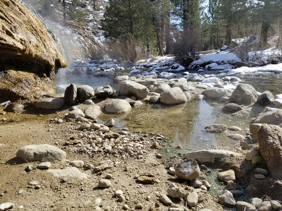
Buckeye Hot Springs beside Buckeye Creek. Image licensed through iStock; licence details retained in the NHSNM image licence log.
Visitor Basics
- Natural geothermal hot springs near Bridgeport, California.
- Located in Mono County within the Humboldt-Toiyabe National Forest.
- Managed through the Forest Service's Bridgeport Ranger District.
- Primitive creekside setting rather than a developed thermal resort.
- Source water is extremely hot before cooling and mixing near the creek.
- Access normally involves an unsealed road and short walking approach.
- Wet rock, creek banks and informal soaking areas can be slippery and uneven.
- A vault toilet is available at the Buckeye Hot Springs parking area according to Mono County's winter recreation information.
- There is no potable water at nearby Buckeye Campground.
- Carry out rubbish and leave the site cleaner than you found it.
Entry, Rules, and Conditions
Buckeye Hot Springs is a public-land geothermal recreation site rather than a commercial attraction.
Access conditions can change because of snow, mud, road closures, wildfire, maintenance work or other Forest Service restrictions.
Visitors should use established roads, parking areas and trails, respect posted restrictions and avoid creating new routes across the surrounding landscape.
Mono County states that overnight parking and camping are not permitted within the Buckeye Hot Springs parking area.
Access check: Review current Humboldt-Toiyabe National Forest and Mono County information before making a special trip.
Spring Type and Water
Buckeye Hot Springs is a genuine natural geothermal spring system.
Historical geothermal records identify Buckeye as a natural spring and record water at approximately 60°C / 140°F.
The Forest Service description says the hot spring emerges above Buckeye Creek over a rock overhang, creating a cave-like area around the pool below. Another smaller spring occurs upstream.
The hottest water can cause serious burns. Temperatures in creekside soaking areas can be lower because geothermal water cools and mixes with colder water.
Visitors should physically test the water before entering rather than relying on a published source temperature or a previous visitor report.
Winter Access
Winter can change Buckeye access substantially.
Mono County operates the Buckeye Winter Trail system when snow conditions allow. During winter-trail operations, Buckeye Road can be closed to wheeled vehicles.
The county warns that snowy or muddy road surfaces can become impassable even for four-wheel-drive vehicles and that driving past closure points can damage the road and create serious recovery problems.
Winter visitors may need to park at the designated staging area and continue by permitted non-motorised or winter-trail access.
Conditions vary from year to year, so check the current Buckeye Winter Trail status rather than assuming a closure date.
Safety and Etiquette
- Remember that source water is extremely hot.
- Test water temperature carefully before entering.
- Move away from water that feels excessively hot.
- Do not assume a pool is safe because other people are soaking in it.
- Take care on wet, mineral-coated, muddy and uneven surfaces.
- Creek levels and current can change after storms or snowmelt.
- Closely supervise children around hot water and moving creek water.
- Carry drinking water; do not rely on the hot spring or creek as a potable-water source.
- Respect seasonal road closures and do not drive around gates or barriers.
- Use established access routes and parking areas.
- Pack out rubbish and avoid damaging natural rock or vegetation.
- Follow all current Forest Service fire restrictions and closure notices.
Forest and Environmental Respect
Buckeye Hot Springs sits within a national-forest landscape beside Buckeye Creek.
The Forest Service has previously carried out recreation improvements in the Buckeye Hot Springs area to address erosion, rubbish, sanitation and damage caused by unmanaged visitor use.
That work has included improving the parking area, concentrating access onto a defined trail and reducing unnecessary user-created tracks.
Visitors can help by staying on established routes, using the provided sanitation facilities, carrying out rubbish and avoiding further alteration of creek banks, vegetation and geothermal features.
Black bears also occur in the wider Buckeye area. Campers using nearby Buckeye Campground should follow current food-storage requirements.
Best Time to Visit
Buckeye offers different conditions throughout the year.
Late spring through autumn generally avoids the most complicated winter-road conditions, but weather can still affect the unsealed approach.
Summer may bring warm daytime temperatures, wildfire restrictions and busy recreation periods.
Autumn can offer cooler conditions before heavier winter weather arrives.
Winter can be scenic but access may change to a groomed winter-trail system with Buckeye Road closed to wheeled vehicles.
There is no guaranteed best date. Check current road, weather, fire and Forest Service information before travelling.
Nearby Attractions
- Travertine Hot Springs.
- Bridgeport.
- Buckeye Creek.
- Hoover Wilderness access from the wider Buckeye area.
- Twin Lakes.
- Eastern Sierra scenic drives.
- Bodie region.
- Mono Lake region.
Where to Stay Nearby
Buckeye Campground is the closest Forest Service campground associated with the hot-springs area.
The campground is located on Buckeye Creek and offers basic campsites, picnic tables, fire rings, vault toilets and seasonal garbage service. Recreation.gov states that the campground does not have potable water.
Opening and closing dates depend heavily on weather conditions.
Bridgeport is the closest practical town for motel-style accommodation, food, fuel and other road-trip services.
Do not camp or sleep overnight in the Buckeye Hot Springs parking area. Mono County specifically states that overnight parking and camping are not permitted there.
FAQ
Is Buckeye Hot Springs natural?
Yes. Buckeye is a natural geothermal spring system near Bridgeport in California.
How hot is Buckeye Hot Springs?
Official Forest Service information lists the hot spring at approximately 140°F / 60°C at the source. Creekside soaking areas can be cooler and variable.
Can you soak at Buckeye Hot Springs?
Recreational soaking occurs at the site, but visitors must test water carefully, follow current Forest Service instructions and avoid dangerously hot water.
Where is Buckeye Hot Springs?
It is west of Bridgeport in Mono County, California, within the Humboldt-Toiyabe National Forest.
Who manages Buckeye Hot Springs?
The site is on the Humboldt-Toiyabe National Forest within the Bridgeport Ranger District.
Is Buckeye Hot Springs a developed spa?
No. It is a primitive outdoor geothermal soaking area beside Buckeye Creek rather than a commercial thermal resort.
Can you drive to Buckeye Hot Springs in winter?
Not always. Buckeye Road can close to wheeled vehicles during winter-trail operations, and snow or mud can make the road impassable. Check current Mono County and Forest Service information.
Can you camp at the hot-springs parking area?
No. Mono County states that overnight parking and camping are not permitted within the Buckeye Hot Springs parking area. Use a legal campground or other permitted camping location.
Is there drinking water?
Do not rely on the hot spring or creek for drinking water. Nearby Buckeye Campground is listed as having no potable water.
What other hot spring is near Buckeye?
Travertine Hot Springs is another natural geothermal site near Bridgeport and makes a logical companion stop when conditions allow.
Sources / Last Checked
Primary sources checked:
- Recreation.gov / Humboldt-Toiyabe National Forest — Buckeye Campground and Buckeye Hot Springs.
- U.S. Forest Service — Humboldt-Toiyabe National Forest.
- Mono County — Buckeye Winter Trail and seasonal access information.
- California geothermal spring records — Buckeye Hot Springs classification, approximate coordinates and recorded source temperature.
Images: Two Buckeye Hot Springs photographs licensed through the site owner's iStock account. Licence details are retained in the NHSNM image licence log.
Last checked: 4 September 2026.
Publishing note: Re-check Humboldt-Toiyabe National Forest closures, Mono County Buckeye Road conditions, weather and fire restrictions immediately before changing this page from draft to published.